Le Riou Bourdoux (seen from Pra Loup)
In its fury of an alpine torrent, the Riou Bourdoux reveals the fragility of the landscape

A link in the history of the Alps….
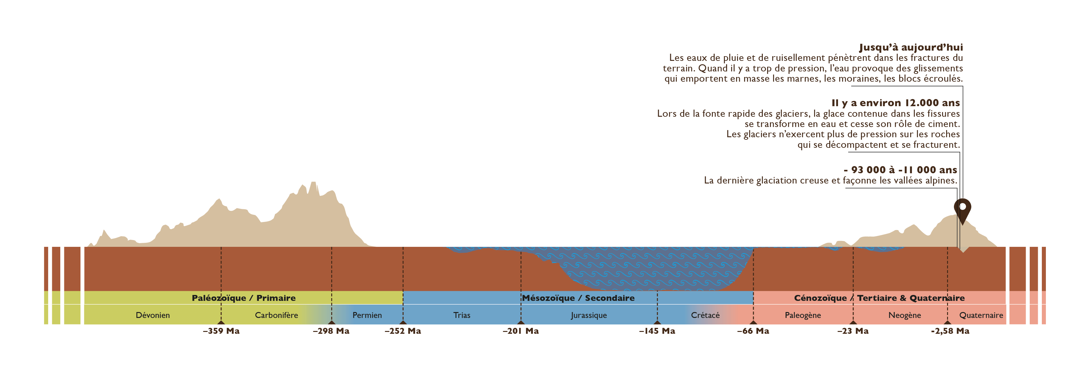
Glaciers have carved and shaped the Alpine valleys. The traces of the last glaciation, approximately -115 to -000 years ago, are still very visible in Ubaye.
Since the glacier melted, the landscape in Ubaye has changed and marks the history of catastrophic events. The torrential activity there is impressive and feared.
From its source near the Franco-Italian border at Col de Longet, after a long tumultuous journey through deep valleys and narrow gorges, the torrent of Ubaye arrives in the very open valley of Barcelonnette.
This valley is carved out of Jurassic black soils (-168 to -158 million years ago). These large, very thick marl assemblages are fractured and, therefore, very fragile to erosion.
The Black Lands support large rocky groups that have crushed them. These sets, pushed and carried over several hundred kilometers by tectonics, are called thrust sheets. Their displacement took place in several stages, between -35 and -5 million years.
The rapid melting of the glacier about 12 years ago had several consequences:
- Due to the cessation of the pressure exerted by the ice, the black lands of the slopes relaxed, decompressed and fractures opened;
- the ice in the cracks in the rock has melted. It no longer played its role of cement between the blocks;
- the slopes have weakened.
Until today, rainwater or snowmelt penetrates the fractures. They accumulate inside the slopes. When the pressure is paroxysmal, it drives out everything that previously contained them. The resulting mass landslides carry with them the marls, the moraines and blocks that have fallen from the thrust layers.
The torrents dig their beds in these active landslides or in old landslides. The materials are washed away during violent storms and flows of boulders and sludge rush downstream.
The Riou Bourdoux torrent west of Barcelonnette is famous for its historic torrential floods. Upstream, it has a receiving basin followed by a channel in its middle part, ending downstream with a very large alluvial cone.
… In connection with 22 other geosites
The Ubaye glacier contributed to the digging and widening of the valley by reaching the black soils which it largely cleared, sweeping away entire sections of marl.
When the glaciers are confronted with very harsh rocky environments, the landscape is then very different: the valleys are boxed in in the shape of a U, with glacial locks (rocky ridges at the bottom of the valleys) and sheep rocks. You can enjoy these landscapes at Lac d'Allos or at Eaux-Tortes in Laverq.
What we can decipher from the current landscape
At the end of the XIXrd century, landslides and torrential floods in the Alps, then bare, were at the origin of the policy of reforestation of massifs launched by the Ministry of Agriculture.
The Riou Bourdoux has been the subject of numerous works to stabilize the land in the axis of the torrent. Today, we can discover these developments thanks to a discovery trail. The continuous sitee be subject to monitoring and intervention by the RTM (Mountain Land Restoration) service of the ONF. Many studies are currently being carried out in partnership with various universities.
A little anecdote?
"The Riou Bourdoux, famous throughout the country for its devastation, is the most terrible and the most considerable torrent of all those in action in the Alps" (P. Demontzey, 1894).
Prosper Demontzey, father of Mountain Land Restoration and Water and Forest engineer, was behind the first reforestation in the “Basses-Alpes”. The Demontzey Park can be discovered at the Col du Labouret, 25 km north of Digne-les-Bains, in the direction of Barcelonnette.